


Hurricane Beryl: A Record-Breaking Indication of a Warming World
Hurricane Beryl has unleashed devastation across the Caribbean, bringing the impact of climate change into sharp focus. With maximum sustained wind speeds surpassing 160 mph (257 km/h), it has become the earliest recorded category five Atlantic hurricane in the past century. Historically, the only other category five Atlantic hurricane in July was Hurricane Emily on July 16, 2005.
Understanding the causes of individual storms is complex, making it challenging to attribute specific hurricanes directly to climate change. However, abnormally high sea surface temperatures are a significant factor behind Hurricane Beryl’s strength. Typically, such intense storms develop later in the season after summer heats the seas.
Hurricanes generally require sea surface temperatures of at least 27°C to form. As illustrated in the map below, the waters along Hurricane Beryl’s path have been exceptionally warm for this time of year.
(Map of sea temperatures along Hurricane Beryl’s path across the Atlantic, highlighting unusually warm waters.)
Warmer seas inherently lead to more powerful hurricanes, as the storms draw more energy, resulting in higher wind speeds. “As we warm the planet, we’re warming our sea surface temperatures as well,” says Andra Garner, assistant professor at Rowan University. “Those warm ocean waters are a critical fuel source for hurricanes.”
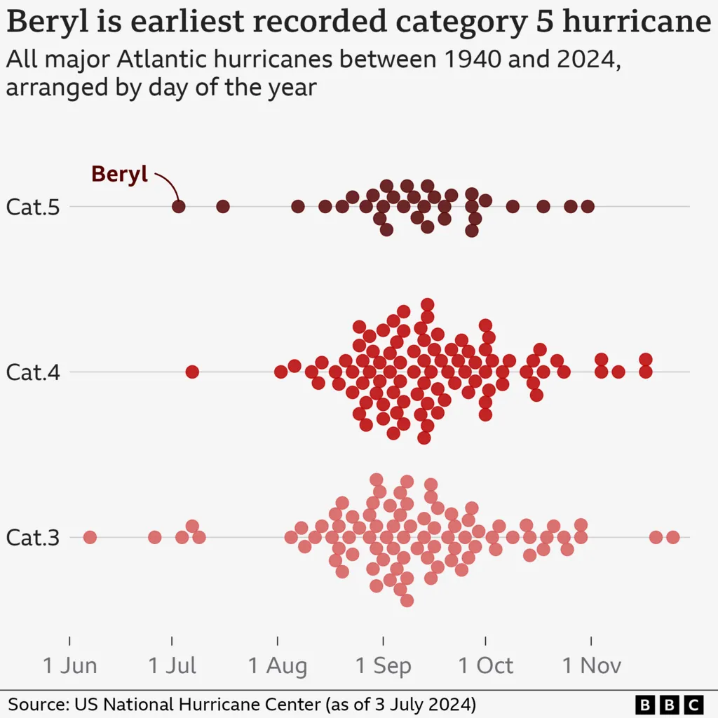
In the main Atlantic hurricane development region, the ocean heat content is at levels usually seen in September when the Atlantic hurricane season peaks. This pattern is shown in the chart below, with each dot representing a major hurricane from 1940 to 2024. Most major hurricanes occur in late August and September, with early-season hurricanes being quite rare.
(Chart illustrating the timing of major hurricanes since 1940, with most occurring around early September.)
While a category five hurricane this early in the season is unprecedented, its intensity aligns with the broader trend of increasingly powerful storms in a warming world. Although the number of hurricanes hasn’t risen, a higher proportion of them are expected to reach the highest categories globally as temperatures rise.
“Although it is uncertain to what extent climate change contributed to the early formation of Hurricane Beryl, our climate models suggest that the mean intensity of hurricanes will increase in the future due to enhanced global warming,” explains Hiroyuki Murakami, a research scientist at NOAA’s Geophysical Fluid Dynamics Laboratory.
Regional weather patterns are another critical factor this year. Recently, El Niño conditions in the eastern Pacific have ended.
What is El Niño and how does it change the weather? Is climate change making hurricanes worse?
El Niño typically suppresses the formation of strong hurricanes in the Atlantic due to its impact on atmospheric winds. Conversely, La Niña promotes Atlantic hurricane development. Currently, we are in “neutral” conditions, but La Niña is expected to return later this year.
This likely transition, coupled with rising sea temperatures through July and August, raises concerns about the potential for more powerful hurricanes later in the season. “Hurricane Beryl sets a precedent for what we fear will be a very active and dangerous hurricane season, impacting the entire Atlantic basin,” says Ko Barrett, Deputy Secretary-General of the World Meteorological Organization.
In May, NOAA warned of an “extraordinary” Atlantic hurricane season, predicting four to seven major hurricanes (category three or above) between June and November, compared to the average of three major hurricanes annually.
Rapid Intensification
Meteorologists and climate scientists have also noted the rapid intensification of Hurricane Beryl. It transformed from a tropical depression (with wind speeds of 38 mph or less) to a major hurricane (above 111 mph) in just 42 hours.
“What makes Beryl particularly notable is its rapid intensification from a tropical depression to a hurricane, the fastest of any Atlantic hurricane in June or early July,” explains Shuyi Chen, professor of atmospheric science at the University of Washington.
Hurricane Beryl exemplifies “rapid intensification,” where wind speeds increase quickly, giving communities less time to prepare. The frequency and magnitude of these events in the Atlantic have risen in recent decades.
“Unprecedented as Beryl is, it aligns with the extremes we expect in a warmer climate,” says Dr. Garner. “As we warm the planet, we’re stacking the deck of extreme events against ourselves, making hurricanes like Beryl more likely.”
“It’s up to us to reduce our emissions to change that story.”


